
13 May, 07 – 21.54
15.5181N,49.5855W
24 hr progress: 15.9 Nautical Miles (1 nm = 1.85 km)
Distance left to Antigua (straight line): 682 Nautical Miles ( 1261 km)
Distance completed: 2509 NM (4641 km)
Wave height: 10-15 ft, Winds: 15-18 knots NE, Bearing: 260-270degrees.
In all, quite a surreal atmosphere on board. Not a single ray of sunlight to be seen all day. The sun has been hidden behind a thin layer of Altostratus clouds – fairly thick clouds forming a grayish veil over the sky. The only visual all day has been a watery disc in the sky, just a bright blurry spot moving across the sky and a very gray sea. Looks like the Sun has taken the Sunday off as well.
I'm averaging 15 nautical miles a day without the rudder. Painfully less than my average of 30 nautical miles a day before I took the rudder out. The gameplan is to get within 300 miles of Antigua (rescue distance) before putting the rudder back in and making a last dash for shore before the fiberglass gives in completely. 30 days more to go!
I had a few messages asking me about the latitude and longitude figures that I post on here. So here's a quick explanation of my course to put the numbers into perspective.
I started from the island of El Hierro which is at N27, W018 setting course for Antigua at which lies at 17N, 61W.
In a motor boat or in a perfect world :), I would have traveled in a straight line (the fastest route) between the two points.
Rowing across the Atlantic is very much influenced by the prevailing winds and ocean currents at different latitudes.
When I left El Hierro, I had 3 options a) try and steer the boat in a straight line towards Antigua b) maintain a northern route and “touching down” to Antigua from the North East or c) follow a southern course - a more U- shaped course where I row below the latitude of Antigua and then row back up again approaching the island from the South East.
I have 4 Pilot charts on board for the North Atlantic covering March, April, May, June showing the currents and wind speeds at different times of the year. On comparing trends for the wind and currents, I found the North Equatorial Current increasing in strength (to about 1.5 knots) and curving off more to the North as the period of May-June progressed.
I compared this with the ships log of Graham Walters, who had chosen to follow a Northern route to Antigua. From the log, it seemed he was having trouble making progress South towards Antigua due to the currents moving northward. I spoke to a few other people, Rune, Erden Eruc who confirmed favorable prevailing winds at that time of the year for a SE approach.
Therefore, at El Hierro, I decided to set a Southern course for Antigua, betting that the wind and currents turn out as advertised. I followed the Canary Current south from El Hierro, down to the Cape Verde islands, where I got hold of the North Equatorial Current.
Over the next few days, as I get closer to the Caribbean, I hope to catch the SE Antilles current.
The currents have performed as advertised, working at 0.5 – 1 knot in my favor. The winds have been consistently astern, varying between gale conditions and a light breeze. However a few shifts between NE and SE, causing a confused sea and difficult rowing conditions.
At my current position from my current position is 15.51N, 49.58W, I am 2 degrees(approx 120 nm) South of Antigua and 600 nautical miles to the W. My next big milestone is crossing the 50 degrees W, which will be a great psychological lift and give a sense of being closer to achieving the goal.
Back to the oars for now,
B
Confused by any of the terms? Visit the Glossary: http://www.bhavik.com/crossatlantic/about_glossary.htm
To send me an SMS message (160 chars) via my satellite phone 881631582692 go to http://messaging.iridium.com/
Or you can post me a longer personal message via my webpage which will be forwarded to me within 48 hours.
http://www.bhavik.com/crossatlantic/messages.asp
Otherwise email me: mail@bhavik.com
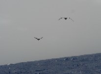
Terns fishing near the boat
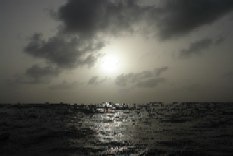
Altostratus clouds - 2.5 km
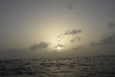
Blurred sun all day
No comments:
Post a Comment