
13 June, 07 – 15.30 GMT
17.1592N,61.0980W
Distance left to Antigua (straight line): 33 Nautical Miles ( 61 km)
POSTED AT 21.00 hrs IST, 15.30 hrs GMT, 12.00 Local Time, Antigua
I rowed past my final meridian at 61W last night and all of a sudden my row seems to be ending much faster.
Its been quite a bumpy ride over the past 12 hrs. I've been rowing at a 45 degree angle to the waves all night (as opposed to following waves) trying to make progress South West. It felt like riding one of those Bajaj three wheelers on the surface of the moon and the salt sores on my rear were running for cover :)
Navigating without a motor or sail across 3000 miles ocean has been quite a daunting task. Its been a constant fight for control between the oars and the elements of the nature. Added to that Antigua is quite a difficult target to hit. Its one of the smallest islands in Caribbean measuring just 12 miles from North to South.
I'm now just 33 miles from the destination I chose 2 years ago. I'm very pleased that my choice of route (I chose a longer Southerly route as opposed to straight line or Northerly route) and zig zag adjustments for winds and currents along the way have turned out right. (...and some of you messaged me saying I was obsessing too much??? :)
The next bit of the challenge is getting into port.
The original plan was to stay South of Antigua (Around N16.3000 deg) until I was around 20 miles away and then follow a gradual gradient to make progress North West (bearing 270-290) towards English Harbour. My calculation was based on factoring in 0.5 knot north equatorial equatorial current turning NE and 10-15 knot winds from the E or SE
Unfortunately, restoring things after the capsize took up valuable time at the oars. The severe squalls and winds predominantly from the SE over the past few days have also pushed me further North West (I am now past the latitude of Antigua).
So, its been back to the drawing board. I've fixed the rudder back for one last time hopefully, so steering is a little easier. I have three options. The first, to row South West on a bearing of 220-240 till I am back on level with Antigua. Or the second option, which is to continue North West of Antigua till I am on lee of the Island and then make progress backwards in a mild headwind. Third, to drop anchor and wait until Friday, when the wind starts blowing from the East.
At present I am trying to row South West. I'm parallel to the waves but the wave height is manageable for now.
There is still some work left ahead. The other factors that complicate the landing is the wind around the islands and the tidal currents. If I miss Antigua and the headwind is more than 10 knots, it will be almost impossible to row backwards. My next options would be the islands of St Martin. Anguilla or the US Virgin Islands.
Will tell you how it goes in the next few hours...
B
WEATHER FORECAST:
OFFSHORE WATERS FORECAST FOR THE SOUTHWEST AND TROPICAL NORTH
ATLANTIC AND CARIBBEAN SEA
NWS TPC/NATIONAL HURRICANE CENTER MIAMI FL
530 AM EDT WED JUN 13 2007
OFFSHORE WATERS FORECAST FOR THE CARIBBEAN SEA AND TROPICAL N
ATLC FROM 7N TO 22N BETWEEN 55W AND 65W
AMZ087-131530-
TROPICAL N ATLC FROM 7N TO 22N BETWEEN 55W AND 65W
530 AM EDT WED JUN 13 2007
TODAY THROUGH THU NIGHT
S OF 17N E WINDS 15 TO 20 KT.
N OF 17N SE WINDS 15 KT.
FRI
S OF 17N E WINDS 15 KT. SEAS 8 FT IN E SWELL.
N OF 17N E TO SE WINDS 10 TO 15 KT.
SAT AND SUN
E WINDS 15 TO 20 KT. SEAS TO 8 FT IN E SWELL.
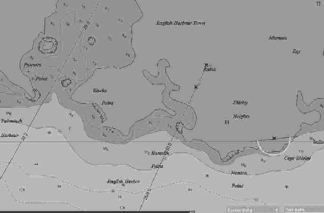
Cmap view English Harbour
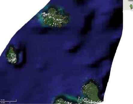
Position on Google Earth, marked by Green Arrow in the top left corner
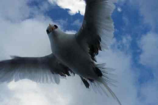
The variety of birds around the boat keeps increasing as I get closer to land
No comments:
Post a Comment